RMNP Bouldering Areas
1 route and 156 boulder problems · granite (Silver Plume Granite) · 10,201 ft
What's here
VB to V14, with no single grade dominating.
Counted from the 156 climbs here that carry a grade. Shown only where there are at least 5 of them — below that the shape is noise.
How well located
Base placed (one source) 10 Position on wall known 78 Crag only 69
The order of the climbs along this wall is known from the open catalogue, so a few surveys go a long way: standing at Fraiche Arete, Carcosa (2 climbs, about 60 seconds on Creme Fraiche Boulder) would place up to 7 more climbs between them. Survey the wall →
“Up to” because the estimate between two surveyed routes is only used when they turn out to be close enough together on the ground.
On the map since 1915
The USGS has mapped this ground since 1915. 29 historical sheets cover this crag's map point; the oldest is below.
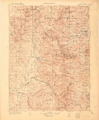
USGS Historical Topographic Map Collection · Public domain · the record · placed by its coordinates
Report this item
Hidden as soon as you tell us, everywhere it appears, before anyone reviews it.
Public domain, U.S. Geological Survey. The sheet shows the ground as the survey found it then, which is why a trail or road you know may be missing. Every sheet over this point, 1915 to 1984: USGS topoView.
In print since 1877
1877 Geologic Map of Colorado (Hayden), high-resolution scan · F. V. Hayden; scan by the Colorado Geological Survey · 1877
Geological and geographical atlas of Colorado and portions of adjacent territory · F. V. Hayden, U.S. Geological and Geographical Survey of the Territories · 1877
Mountaineering in Colorado: the peaks about Estes Park · Frederick H. Chapin · 1889
Trail and Timberline, volume 2 (1918) · Colorado Mountain Club · 1918
Mountaineering in the Rocky Mountain National Park · Roger W. Toll, U.S. National Park Service · 1919
Free to read: public domain or government work. About Alpine Rock as a whole, not this wall. More in the reading room.
Photographs near this crag
Taken within 1.5 km of this crag's map point and published under a licence that lets us show them, from Wikimedia Commons. The coordinates say where the camera was, not what it was pointed at, so some of these will be the creek or the trail rather than the rock.


Wikimedia Commons · CC BY · the record · placed by its coordinates
Report this item
Hidden as soon as you tell us, everywhere it appears, before anyone reviews it.
Wikimedia Commons · CC BY · the record · placed by its coordinates
Report this item
Hidden as soon as you tell us, everywhere it appears, before anyone reviews it.
Wikimedia Commons · CC BY · the record · placed by its coordinates
Report this item
Hidden as soon as you tell us, everywhere it appears, before anyone reviews it.
Wikimedia Commons · CC BY · the record · placed by its coordinates
Report this item
Hidden as soon as you tell us, everywhere it appears, before anyone reviews it.
Wikimedia Commons · CC BY-SA · the record · placed by its coordinates
Report this item
Hidden as soon as you tell us, everywhere it appears, before anyone reviews it.
Wikimedia Commons · CC BY-SA · the record · placed by its coordinates
Report this item
Hidden as soon as you tell us, everywhere it appears, before anyone reviews it.
Wikimedia Commons · CC BY-SA · the record · placed by its coordinates
Report this item
Hidden as soon as you tell us, everywhere it appears, before anyone reviews it.
Wikimedia Commons · CC BY-SA · the record · placed by its coordinates
Report this item
Hidden as soon as you tell us, everywhere it appears, before anyone reviews it.
Wikimedia Commons · CC BY-SA · the record · placed by its coordinates
Report this item
Hidden as soon as you tell us, everywhere it appears, before anyone reviews it.
Wikimedia Commons · CC BY · the record · placed by its coordinates
Report this item
Hidden as soon as you tell us, everywhere it appears, before anyone reviews it.
Wikimedia Commons · CC BY · the record · placed by its coordinates
Report this item
Hidden as soon as you tell us, everywhere it appears, before anyone reviews it.
Wikimedia Commons · CC BY · the record · placed by its coordinates
Report this item
Hidden as soon as you tell us, everywhere it appears, before anyone reviews it.
18 more on Commons.
Routes
50-50 Boulder
- 1 Cat Dance Stand V8+
- 2 Mysteries and Insanity V10
Baby Otech Boulder
- 1 Baby Otech V10
- 2 Fizzy Lifting Drink V7
- 3 Fizzy Lifting Drink jump start V3
Battlebug Boulder
- 1 Not Bacon Wall V5
Bear Lake
- 1 Crowd Pleaser V3
- 2 Hey Bear! V4-5
Bush Pilot Boulder
- 1 Bush Pilot V11
- 2 Freaks of the Industry V13
- 3 Freaks and Geeks V7
- 4 Right Side Warm-ups V0-1
Bushpilot Warm Up Boulder
- 1 Warm Up V3 V2
- 2 Warm Up V6 (Autopilot?) V6
Colossal Boulder
- 1 Flying Piñata V12
Creme Fraiche Boulder
- 1 Fraiche Arete V6
- 2 Wheel of Fraiche V4
- 3 Non-Dairy Wheel of Fraiche V6
- 4 Wheel of Lean V8
- 5 Creme Fraiche Traverse V2
- 6 Cookies and Creme Fraiche V5
- 7 The Shake Weight V1
- 8 Panzotopanzanite V2
- 9 Carcosa V7
Deep Puddle Dynamics
- 1 Deep Puddle Arete V5
- 2 Deep Puddle Dynamics V9+
Emerald Lake
- 1 The End V7-
- 2 Kind Traverse, The V11-
- 3 Mr. Wimpy V7
- 4 Mr. Wimpy SDS V8
- 5 The Kind (originally In Your Face, then Standard Overhang - after the block was removed) V5
- 6 Kind of a Big Deal V9-
- 7 Warm Up V1
European Human Being Boulder
- 1 European Human Being V12
Geeks of the Industry Boulder
- 1 Interference aka Geeks of the Industry V6+
Gobot Boulder, The
- 1 Gobot V11
- 2 Slowbot V9
- 3 Autobot V5-
Golden Rows of Flows Boulder
- 1 Golden Rows of Flows V10
Green Slab Wall
- 1 The Startup V4
- 2 The Standout V3
- 3 The Dugout V2
- 4 Cracked Lips V2
- 5 Pocket Problem V3
- 6 Left Hand of Darkness V6
- 7 Body Surfing V3
- 8 Green Dragon V5
- 9 Green Slab V1
Hanging Arete Boulders
- 1 Cove Over V5-
KB Boulder - Hollowell Park
- 1 Snizzle Sticks V7
- 2 Thai Sticks V5
- 3 KB V8
- 4 V4 Crack V4
Little Orb
- 1 Left V1 V1+
- 2 Right V1 V1
Lone Star
- 1 Lone Star (submitted as Stinkbug) V10-11
Outcast
- 1 The Outlier V3-4
Potato Chip Boulder, The
- 1 Middle Warm up V1
- 2 Potato Chip Layback V3
- 3 Potato Chip Layback Sit (The potato layup) V4
- 4 Potato Chip Pinch V4
- 5 Potato Chip Sit Start V8
- 6 Potato Chip V7-
- 7 Unknown V5-6
- 8 The Crack of Noon V0
Revenge Area
- 1 Counter Attack * V5+
- 2 Warm Up V3
- 3 Malice * V2
- 4 Sneak Attack * V0+
- 5 Revenge V6
- 6 In The Light V8
Skipper Roof
- 1 Skipper G V9
- 2 Skipper D V8
Skyscraper Boulder
- 1 Skyscraper V5
Suzuki Boulder, The
- 1 The Grand Piano V9-
- 2 Southeast Arête V3
Travesse Roof
- 1 Travesse V7
Unknown Boulder
- 1 Erin's Route V0-
Unnamable, The
- 1 Molloy V1
- 2 Molloy Dyno V1-2
Veritas
- 1 Bulgin' Out V8
- 2 Menwax V7
- 3 Veritas Left Sit (Assis) V12
- 4 Mandix V10
- 5 Veritas Assis V11
- 6 Veritas V8+
- 7 Stripes V9
Warm-Up Boulder
- 1 V5 V5
- 2 V4 V4
Elsewhere at this crag
- The Terror and The Joy 5.11-
- 1000 Shades of Green V9
- And I Thought, What the F*ck V6
- Bad Guides V0
- Beginner's Luck V2
- Brimstone V6
- Cove Hang V5-
- Dawn Patrol V4-5
- Don't Get Too Greedy V13
- East Face V3
- Emerald City V0-
- Far Left El Jorge/The Core V8
- Future Development V10
- Government Cheese V7
- Green 45 Stand V10
- Handicapps V9
- Herm's Problem V8
- Invisibility Cloak V9
- It's Fun to Do Bad Things V0
- Jade V14
- Kneebar V6
- Left El Jorge V11
- Leopard Print V3
- Lip Traverse V7-
- Lobster Claw V4
- Lobster Tail V4
- Marble V10-
- Marble Direct V10
- Mikala V7-
- Northwest Corner V3
- Nuthin' But Sunshine V13
- Purple Drank aka Arete V8 V7+
- Real Large V9
- Riddle Solved V11
- Riddles In The Dark V10
- Riddles in the Park V12
- Right El Jorge V8
- Rocky Mountain Beaver Fever V1
- Secret Splendor V12
- South Face V1
- Spite * V2+
- Storm Shadow Stand V10
- Swang of Thangs V4+
- Swing of Things V7
- Taurus V6-7
- The Automator V13
- The Bread Loaf V5
- The Breadoaf V5
- The Centaur V12
- The Cube V5 V5-
- The Cube V6 V6
- The Dividing Line V0
- The Example V1+
- The Fuzz is the Fire V4
- The Kind sitstart V7-
- Tiger Stripes V5-6
- Tommy's Arete V7
- Tommy's Arête Right Exit V6
- Tommy's Other Arete V9
- Tommy's Warm-up V3
- Top Notch V13
- Trick Nasty V1-
- Warm Up Cave V5-
- Warm-Up Boulder V1
- Whispers of Wisdom V10
- Windy in a Basket V7
- Wyoming Chinese * V7
- [Redacted] V8
Also within 3 km
- Bear Lake Trailheads1,146 m · 17 routes · 9,602 ft · RMNP - Mixed/Ice
- Glacier Gorge Trailhead Ice1,169 m · 9 routes · 10,274 ft · RMNP - Mixed/Ice
- Thatchtop Mountain1,844 m · 1 route · 10,879 ft
- Cathedral Wall2,036 m · 14 routes · 10,833 ft
- Hallett Peak2,152 m · 24 routes · 12,665 ft
- Otis Peak2,186 m · 19 routes · 12,453 ft
Straight line between the two crags' map points, each of which can be some way from its rock. For when this wall is full, or the sun has found it.
Photos from climbers
No photos here yet. If you're at the crag, yours would be the first.
Taken at the crag by climbers and published as they sent them. Each one's own location had to be within 0.5 km of this crag before we accepted it. See something that shouldn't be here? Use Report this photo under it and it's hidden at once. Anything else, write to us.
Conditions reported
Nothing reported recently.
Report what you see
Reports are dated and fade on their own: wet rock after 3 days, a bad bolt after a year. No names, no text.
Access & safety
The map point for this crag is on land managed by National Park Service (federal), in Rocky Mountain National Park. It lies inside wilderness area, national park.
Land manager from USGS PAD-US (public domain), read 2026-09-29. It is the manager of the crag's map point, which can be a long way from the wall. What you may do on the rock is the manager's to say, not ours.
- Managed by
- Rocky Mountain National Park
- Fees
- Park entrance $30/vehicle (1-day) or $70 annual pass.
- Reservations
- Late May to mid-October a timed-entry reservation may be needed, depending on where and when you enter (nps.gov/romo).
- Overnight
- Bivy permits: technical climbers only, climb of 4+ roped pitches and 3.5+ miles from the trailhead, party of 4 or fewer, all climbing. Set up at dusk, down by dawn.
- County
- Larimer County
Checked 2026-09-29 against source 1, source 2. Rules change: confirm with the land manager.
Rules for all Rocky Mountain National Park land
- Fees
- A park entrance pass is required. $30 for one private vehicle for one day, $35 for seven days, or $70 for a park-specific annual pass.
- Reservations
- Timed entry reservations are required 22 May to 12 October 2026, 9 a.m. to 2 p.m. daily, and 5 a.m. to 6 p.m. for the Bear Lake Road corridor (to 18 October). They cover outlying areas including Longs Peak and Lumpy Ridge, not just the main road. $2 processing fee.
- Permits
- A timed entry reservation is separate from, and additional to, the entrance pass -- the park says a valid entrance pass is also required.
Read on Rocky Mountain National Park's own pages, checked 2026-09-29 by John Crawford. What they require, in full, or their own climbing page. These apply to the manager's whole holding; anything specific to this crag is above.
Nearby, from OpenStreetMap
- Toilets
- 1,498 m away (map)
- Campsite
- Andrews Creek, 1,668 m away (map)
Distances are a straight line from this crag's map point, which can itself be hundreds of metres off; a road may be much longer. Mapped by OpenStreetMap contributors (ODbL), so a toilet missing here may simply be unmapped. Parking here is what OSM has drawn nearby, not a guidebook's directions.
Keep Deep Cut Guide free
No ads, no paywall, no account. You can chip in directly to help keep it running.