Bear Lake Trailheads
17 routes · Biotite schist · 9,602 ft
What's here
5.5 to 5.14, mostly around 5.12.
Counted from the 14 climbs here that carry a grade. Shown only where there are at least 5 of them — below that the shape is noise.
How well located
Base placed (one source) 2 Position on wall known 15
The order of the climbs along this wall is known from the open catalogue, so a few surveys go a long way: standing at Dingleberry Crack, Grizzly (2 climbs, about 60 seconds on Bear's Den) would place up to 3 more climbs between them. Survey the wall →
“Up to” because the estimate between two surveyed routes is only used when they turn out to be close enough together on the ground.
Rock, from the geologic map
Biotite schist — metamorphic. Paleoproterozoic, about 2,500 to 1,600 million years old.
Conspicuously banded rock marked by alternating layers of contrasting composition; dark-gray to black, medium- to coarse-grained layers are rich in biotite, sillimanite, and magnetite; light- to medium-gray or bluish-gray, fine-grained layers contain more quartz and feldspar than biotite; white, coarse-grained layers consist of quartz and feldspar and minor biotite. Weathers to mottled reddish or yellowish brown. Layering is typically folded into moderate warps and tight flexures and isoclines. Protolith consisted of alternating beds of shale, siltstone, and sandstone. Regional metamorphism at about 1,700 Ma (Peterman and others, 1968, p. 2284) produced characteristic mineral assemblages that vary across the region depending on maximum local temperature and pressure. Northeast of the North Fork Big Thompson River, maximum temperature of metamorphism was as low as 525 degrees C (J.W. Drexler, oral commun., 1986), partial melting was not initiated (migmatite is absent), and the typical prograde assemblage consists of quartz, plagioclase, lepidoblastic muscovite, biotite, staurolite, andalusite, and iron oxides. Throughout most of map area, peak temperatures probably exceeded 700 degrees C (Nesse, 1977, 1984), anatectic melting was widespread (migmatite is ubiquitous), and typical mineral assemblage contains quartz, plagioclase, microcline, sillimanite, biotite, +/- garnet, +/- cordierite, hercynite, and iron oxides. Presence of garnet (rare) and (or) cordierite depends on local bulk composition; prograde cordierite appears to have formed by reactions of the type: biotite + sillimanite = cordierite + anatectic melt. Mineral changes between the lower and higher temperature regions are shown by the red dashed-line boundaries: sillimanite is present west of the S boundary, whereas staurolite and andalusite disappear near this boundary; microcline appears and lepidoblastic muscovite disappears at the K boundary; migmatite appears south and west of the M boundary; cordierite is present south and east of an unmapped, broad zone that extends from Eagle Rock (north of Estes Park) through Beaver Meadows, Mount Wuh, Ptarmigan Mountain, and southwestward to the east end of Granby Reservoir. GRI Source Map ID 141 (I-1973). ** Areas where numerous sills, dikes, or irregular bodies of Silver Plume Granite (Ysp) intrude biotite schist (Xs) [indicated by stippled regions on source paper map]. Areas that contain numerous conformable layers of pegmatite (YXp) [indicated by crossed regions on source paper map].
This is the map unit under this crag's map point, read from the 1:100,000 sheet (National Park Service Geologic Resources Evaluation program, 2006, National Park Service). The point can be a few hundred metres from the rock, a cliff often stands on the line between two units, and at that scale a line on the map is about 100 m wide on the ground, so the wall itself may be the neighbouring unit. Every crag on this unit: Biotite schist. Geology data: Macrostrat (CC BY 4.0), serving USGS and Colorado Geological Survey maps.
On the map since 1915
The USGS has mapped this ground since 1915. 29 historical sheets cover this crag's map point; the oldest is below.
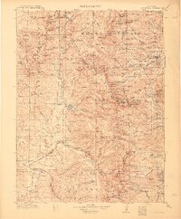
USGS Historical Topographic Map Collection · Public domain · the record · placed by its coordinates
Report this item
Hidden as soon as you tell us, everywhere it appears, before anyone reviews it.
Public domain, U.S. Geological Survey. The sheet shows the ground as the survey found it then, which is why a trail or road you know may be missing. Every sheet over this point, 1915 to 1984: USGS topoView.
Photographs near this crag
Taken within 1.5 km of this crag's map point and published under a licence that lets us show them, from Wikimedia Commons. The coordinates say where the camera was, not what it was pointed at, so some of these will be the creek or the trail rather than the rock.


Wikimedia Commons · CC BY-SA · the record · placed by its coordinates
Report this item
Hidden as soon as you tell us, everywhere it appears, before anyone reviews it.
Wikimedia Commons · CC BY-SA · the record · placed by its coordinates
Report this item
Hidden as soon as you tell us, everywhere it appears, before anyone reviews it.
Wikimedia Commons · CC BY · the record · placed by its coordinates
Report this item
Hidden as soon as you tell us, everywhere it appears, before anyone reviews it.
Wikimedia Commons · CC BY-SA · the record · placed by its coordinates
Report this item
Hidden as soon as you tell us, everywhere it appears, before anyone reviews it.
Wikimedia Commons · CC BY-SA · the record · placed by its coordinates
Report this item
Hidden as soon as you tell us, everywhere it appears, before anyone reviews it.
Wikimedia Commons · CC BY-SA · the record · placed by its coordinates
Report this item
Hidden as soon as you tell us, everywhere it appears, before anyone reviews it.
Wikimedia Commons · CC BY · the record · placed by its coordinates
Report this item
Hidden as soon as you tell us, everywhere it appears, before anyone reviews it.
Wikimedia Commons · CC BY · the record · placed by its coordinates
Report this item
Hidden as soon as you tell us, everywhere it appears, before anyone reviews it.
Wikimedia Commons · CC BY · the record · placed by its coordinates
Report this item
Hidden as soon as you tell us, everywhere it appears, before anyone reviews it.
Wikimedia Commons · CC BY · the record · placed by its coordinates
Report this item
Hidden as soon as you tell us, everywhere it appears, before anyone reviews it.
Wikimedia Commons · CC BY · the record · placed by its coordinates
Report this item
Hidden as soon as you tell us, everywhere it appears, before anyone reviews it.
Wikimedia Commons · CC BY · the record · placed by its coordinates
Report this item
Hidden as soon as you tell us, everywhere it appears, before anyone reviews it.
18 more on Commons.
Routes
Bear's Den
- 1 Dingleberry Crack 5.11+
- 2 Furry Thang 5.12a
- 3 Spider Nutz 5.12
- 4 Smokey 5.12c
- 5 Grizzly 5.12
East Buttress
- 1 Steeplechase 5.5
- 2 Butterfingers 5.7
- 3 Left of Cleft 5.8
- 4 East Ridge 4th
Flattop Mountain - S side
- 1 Enter The Dragon (aka Old Route) 5.7
- 2 Southeast Face Easy 5th
NE Buttress Hallett Peak - mixed/ice
- 1 The Cleft 5.8
- 2 Booby Trap 5.8+
- 3 Ms. Inferno 5.10+
- 4 Krishna Cutoff 4th
Elsewhere at this crag
- North Face (which actually faces NE) 5.7
- Get a File 5.14d
Also within 3 km
- RMNP Bouldering Areas1,146 m · 1 route and 156 boulder problems · 10,201 ft · RMNP - Rock
- Glacier Gorge Trailhead Ice2,085 m · 9 routes · 10,274 ft
- Thatchtop Mountain2,742 m · 1 route · 10,879 ft · RMNP - Rock
Straight line between the two crags' map points, each of which can be some way from its rock. For when this wall is full, or the sun has found it.
Photos from climbers
No photos here yet. If you're at the crag, yours would be the first.
Taken at the crag by climbers and published as they sent them. Each one's own location had to be within 0.5 km of this crag before we accepted it. See something that shouldn't be here? Use Report this photo under it and it's hidden at once. Anything else, write to us.
Conditions reported
Nothing reported recently.
Report what you see
Reports are dated and fade on their own: wet rock after 3 days, a bad bolt after a year. No names, no text.
Access & safety
The map point for this crag is on land managed by National Park Service (federal), in Rocky Mountain National Park. It lies inside wilderness area, national park.
Land manager from USGS PAD-US (public domain), read 2026-09-29. It is the manager of the crag's map point, which can be a long way from the wall. What you may do on the rock is the manager's to say, not ours.
Rules for all Rocky Mountain National Park land
- Fees
- A park entrance pass is required. $30 for one private vehicle for one day, $35 for seven days, or $70 for a park-specific annual pass.
- Reservations
- Timed entry reservations are required 22 May to 12 October 2026, 9 a.m. to 2 p.m. daily, and 5 a.m. to 6 p.m. for the Bear Lake Road corridor (to 18 October). They cover outlying areas including Longs Peak and Lumpy Ridge, not just the main road. $2 processing fee.
- Permits
- A timed entry reservation is separate from, and additional to, the entrance pass -- the park says a valid entrance pass is also required.
Read on Rocky Mountain National Park's own pages, checked 2026-09-29 by John Crawford. What they require, in full, or their own climbing page. These apply to the manager's whole holding; anything specific to this crag is above.
Nearby, from OpenStreetMap
- Toilets
- 569 m away (map)
- Mapped parking
- 680 m away (map)
- Campsite
- Sourdough Campsite, 2,576 m away (map)
Distances are a straight line from this crag's map point, which can itself be hundreds of metres off; a road may be much longer. Mapped by OpenStreetMap contributors (ODbL), so a toilet missing here may simply be unmapped. Parking here is what OSM has drawn nearby, not a guidebook's directions.
Keep Deep Cut Guide free
No ads, no paywall, no account. You can chip in directly to help keep it running.