Weston Pass-(Weston Wall)
7 routes · Dry Union Formation · 9,816 ft
What's here
5.10 to 5.11, but over half of these routes are 5.10.
Counted from the 7 climbs here that carry a grade. Shown only where there are at least 5 of them — below that the shape is noise.
How well located
Position on wall known 7
No route here has its own point yet. The map pin is the crag. At the wall? Survey it: 30 seconds per route.
The order of the climbs along this wall is known from the open catalogue, so a few surveys go a long way: standing at Jams and Jugs, Falcon Derby (2 climbs, about 60 seconds) would place up to 5 more climbs between them. Survey the wall →
“Up to” because the estimate between two surveyed routes is only used when they turn out to be close enough together on the ground.
Rock, from the geologic map
Dry Union Formation. Zanclean, about 5.3 to 5.3 million years old.
Locally tan or orange-brown, gray, reddish-gray, or greenish-gray mostly unconsolidated to moderately consolidated, weakly to well stratified, locally cross-stratified, minor clay and silt, silty sand, sand, and gravel. Clasts composed mostly of Proterozoic gneiss and igneous rocks and Tertiary volcanic rocks, generally less than 10 cm in diameter, but locally much larger. Unit locally contains ash-rich sandstone beds. A detailed sedimentological study of the Dry Union formation in the southern part of the upper Arkansas River valley was carried out by Xu (2001). Com- monly, unit is poorly exposed and is mantled by unmapped deposits of colluvium (Qc) and other mass-movement deposits and, locally, by sheetwash alluvium. Named for expo- sures in Dry Union Gulch, about 7 km south of Leadville (Tweto, 1961). Originally called “lake beds” by early miners that excavated shafts and adits in western part of the Leadville mining district (Emmons and others, 1886; Emmons and Irving, 1907; Emmons and others, 1927). Extensively exposed in southern part of upper Arkansas River valley; but in the northern part is mostly overlain by Quaternary surficial deposits. Generally dips gently west due to general down-dropping of west side of valley along faults. Unit Nd includes reddish-brown to yellowish brown, crudely bedded to well-stratified, cobbly pebble, fluvial gravel that commonly contains quartzite clasts beneath terrace deposits composed of outwash gravel of middle Pleistocene age (Qg3) between Malta and Iowa Gulch in the Leadville South quadrangle (McCalpin, Funk, and others, 2012), where it is correla- tive with the Malta Gravel of Tweto (1961), but here interpreted as upper part of the Dry Union Formation. Thickness probably locally more than 1,600 m in southern part of upper Arkansas River valley (Tweto, 1979a) and possibly as much as 1,200 m in the northern part (Tweto and Case, 1972). Chiefly fluvial deposits and fan deposits are recognized in the northern part of the Arkansas River graben in the Granite quadrangle. The fan deposits locally include alluvium of minor tributary streams, sheetflood deposits, and debris-flow deposits (Shroba and others, 2014). Two distinct facies (northern and south- ern) are recognized in the southern sub-basin of the Arkansas River graben (Shannon and McCalpin, 2006). North of the Salida-Maysville fault system, the Dry Union Formation commonly consists of white, pinkish-white, orange-tan, and light greenish- gray, very fine-grained siltstone, minor sandstone, and thin, discontinuous lenses of pebble to boulder conglomerate. Clasts are as long as 2 m (Shannon and McCalpin, 2006). Beds are as thick as several meters. Unit Nd locally forms extensive eroded, badland topography. This northern facies contains white, fine-grained, massive ash beds as much as about 1 m thick that are mapped at a few localities. Ash beds were sampled at two localities about 1.0–1.5 km south of Salida, yielding ages of 9.30±0.04 Ma and 15.6±0.3 Ma, respectively. These ages and reported mammalian fos- sils ages (using the current subdivision of Neogene time [U.S. Geological Survey, 2010]), the ages of ash- and fossil-bearing beds is inferred to be late Miocene or possibly early Pliocene (Van Alstine, 1974; Shannon and McCalpin, 2006). In addition to very fine- grained siltstone, conglomerate, and minor sandstone, two distinct subfacies are identified south of the Salida-Maysville fault: clay subfacies and slide-block subfacies (Nds). South of Salida-Maysville fault, age of exposed beds may be slightly older than north of the fault, consistent with the down-to-the-north offset on the fault; ash beds in the clay subfacies (Ndc) south of the fault (described below) suggest middle Miocene age. Conglomerate clasts south of the fault typically are much larger than clasts north of the fault. Some clasts south of the fault are as large as 6 m (Shannon and McCalpin, 2006)
This is the map unit under this crag's map point, read from the 1:100,000 sheet (Kellogg and others, 2017, U.S. Geological Survey Scientific Investigations Map 3382). The point can be a few hundred metres from the rock, a cliff often stands on the line between two units, and at that scale a line on the map is about 100 m wide on the ground, so the wall itself may be the neighbouring unit. Every crag on this unit: Dry Union Formation. Geology data: Macrostrat (CC BY 4.0), serving USGS and Colorado Geological Survey maps.
On the map since 1889
The USGS has mapped this ground since 1889. 30 historical sheets cover this crag's map point; the oldest is below.
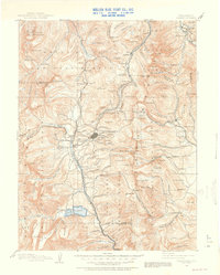
USGS Historical Topographic Map Collection · Public domain · the record · placed by its coordinates
Report this item
Hidden as soon as you tell us, everywhere it appears, before anyone reviews it.
Public domain, U.S. Geological Survey. The sheet shows the ground as the survey found it then, which is why a trail or road you know may be missing. Every sheet over this point, 1889 to 1994: USGS topoView.
Routes
Photos from climbers
No photos here yet. If you're at the crag, yours would be the first.
Taken at the crag by climbers and published as they sent them. Each one's own location had to be within 0.5 km of this crag before we accepted it. See something that shouldn't be here? Use Report this photo under it and it's hidden at once. Anything else, write to us.
Conditions reported
Nothing reported recently.
Report what you see
Reports are dated and fade on their own: wet rock after 3 days, a bad bolt after a year. No names, no text.
Access & safety
The map point for this crag is on land managed by San Isabel National Forest (federal). It lies inside national forest.
The boundary is close. Land managed by Bureau of Land Management comes within 250 m of this point, and the point is not the rock — the wall itself may be on the other side of the line. Check which before you rely on either one's rules.
Land manager from USGS PAD-US (public domain), read 2026-09-29. It is the manager of the crag's map point, which can be a long way from the wall. What you may do on the rock is the manager's to say, not ours.
Rules for all Pike-San Isabel National Forests land
- Fees
- No entrance fee for the Pike-San Isabel National Forests or the Cimarron and Comanche National Grasslands. Fees apply at campgrounds and day-use areas operated by the forest's concessionaire, paid on site.
- Overnight
- On the Leadville, Salida and San Carlos districts of the San Isabel, camping at any location within the same 20-mile radius for more than 14 days in a continuous 30-day period is prohibited. No camping within 100 feet of water outside a developed or designated site.
Read on Pike-San Isabel National Forests's own pages, checked 2026-09-29 by John Crawford. What they require, in full, or their own climbing page. These apply to the manager's whole holding; anything specific to this crag is above.
Nearby, from OpenStreetMap
- Campsite
- Unnamed, 2,770 m away (map)
Distances are a straight line from this crag's map point, which can itself be hundreds of metres off; a road may be much longer. Mapped by OpenStreetMap contributors (ODbL), so a toilet missing here may simply be unmapped. Parking here is what OSM has drawn nearby, not a guidebook's directions.
Keep Deep Cut Guide free
No ads, no paywall, no account. You can chip in directly to help keep it running.