Middle Fork of St. Vrain Canyon
47 routes · granite (Silver Plume Granite) · 8,503 ft
What's here
5.3 to 5.11, mostly around 5.10.
Counted from the 47 climbs here that carry a grade. Shown only where there are at least 5 of them — below that the shape is noise.
How well located
Position on wall known 45 Crag only 2
No route here has its own point yet. The map pin is the crag. At the wall? Survey it: 30 seconds per route.
The order of the climbs along this wall is known from the open catalogue, so a few surveys go a long way: standing at Jesus Camp, Date Climb (2 climbs, about 60 seconds on Glacier View Dome) would place up to 6 more climbs between them. Survey the wall →
“Up to” because the estimate between two surveyed routes is only used when they turn out to be close enough together on the ground.
The guidebook for this area
Rock Climbing St. Vrain Canyons - Bernard Gillett every crag it covers
The book has the topos, the descriptions and the local knowledge this page can't. Buying it helps support the people who know the crag best.
Rock, from the geologic map
Silver Plume Granite — intrusive igneous (plutonic). Mesoproterozoic, about 1,600 to 1,000 million years old.
Light- to medium-gray, grayish-orange, orange-pink, or red-purple monzogranite to syenogranite that contains characteristic tabular microcline phenocrysts. Equigranular matrix is locally fine, medium, or coarse grained, and proportion of phenocrysts is variable throughout the region; flow alignment strong in rocks with abundant phenocrysts. Average mineral composition is similar regardless of texture, and contains 30 percent quartz, 25-28 percent oligoclase, 32-35 percent microcline, 7 percent biotite, trace amounts of magmatic garnet and sillimanite, 1 percent subsolidus muscovite, and minor apatite, monazite, and magnetite. Irregular-shaped outcrop masses in east and central parts of map area form northwest part of the composite Longs Peak-St. Vrain batholith, which extends south to Ward and east to Lyons, Colorado, over an area of more than 1,200 km2. Granite bodies forming the north, northeast, and south parts of batholith generally have steep walls, are sharply discordant, and are characterized by gradual transitions between internal textural varieties. In contrast, granite bodies forming the southwest part of batholith (along Continental Divide) were emplaced as anastomosing, flat-lying sheets that are largely concordant with foliation in the surrounding, gently dipping metamorphic rocks. Silver Plume exposed in the Glacier Gorge-Chiefs Head Peak-Longs Peak-Mount Meeker-Estes Cone region consists of sharply bounded granite sheets that vary in color, texture, or composition, and that are locally separated by thin sheets of metamorphic rock. Granite exposed west of Wild Basin is compositionally more homogeneous, but is surrounded by zones of metamorphic rocks that contain 10-75 percent intrusive sheets or irregular bodies of granite (indicated by pattern on older rocks). Age of the Silver Plume Granite in the Longs Peak-St. Vrain batholith is 1,420+/-25 Ma (Peterman and others, 1968, p. 2289). Several rock types that are believed to be related to the Silver Plume Granite have been mapped in local areas. GRI Source Map ID 141 (I-1973).
This is the map unit under this crag's map point, read from the 1:100,000 sheet (National Park Service Geologic Resources Evaluation program, 2006, National Park Service). The point can be a few hundred metres from the rock, a cliff often stands on the line between two units, and at that scale a line on the map is about 100 m wide on the ground, so the wall itself may be the neighbouring unit. The rock named at the top of this page comes from the public geology of this area; this card is the map's answer. Every crag on this unit: Silver Plume Granite. Geology data: Macrostrat (CC BY 4.0), serving USGS and Colorado Geological Survey maps.
On the map since 1902
The USGS has mapped this ground since 1902. 27 historical sheets cover this crag's map point; the oldest is below.
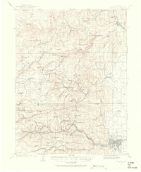
USGS Historical Topographic Map Collection · Public domain · the record · placed by its coordinates
Report this item
Hidden as soon as you tell us, everywhere it appears, before anyone reviews it.
Public domain, U.S. Geological Survey. The sheet shows the ground as the survey found it then, which is why a trail or road you know may be missing. Every sheet over this point, 1902 to 1984: USGS topoView.
Photographs near this crag
Taken within 1.5 km of this crag's map point and published under a licence that lets us show them, from Wikimedia Commons. The coordinates say where the camera was, not what it was pointed at, so some of these will be the creek or the trail rather than the rock.


Wikimedia Commons · CC BY-SA · the record · placed by its coordinates
Report this item
Hidden as soon as you tell us, everywhere it appears, before anyone reviews it.
Wikimedia Commons · CC BY-SA · the record · placed by its coordinates
Report this item
Hidden as soon as you tell us, everywhere it appears, before anyone reviews it.
Routes
Black Dog Wall
- 1 Lazy Dog 5.4
- 2 Hazy 5.10-
- 3 Crank Yanker 5.10
- 4 Eddyline 5.8
- 5 Jolly Roger 5.9
Glacier View Dome
- 1 Jesus Camp 5.5
- 2 Mello Yello 5.8
- 3 Orange Crush 5.10-
- 4 Direction of Pull 5.5
- 5 Little Henry 5.3
- 6 Bloody Mary Morning 5.5
- 7 Float Away 5.10-
- 8 Date Climb 5.3
Moose Rock
- 1 Pack Rat Pillar 5.9
- 2 Gravy Legs 5.10+
- 3 Moose Track 5.10
- 4 Insane Rush 5.10+
- 5 Motorcycle Drive By 5.10-
Powerline Alcove
- 1 The Fear of Sharting 5.10-
- 2 White Claw 5.7
- 3 Crystal Pillar 5.8
- 4 Mr. Inflexible 5.9
- 5 Electric Cowboy 5.10-
- 6 Ground Anchor 5.10-
- 7 Leaf Peeper 5.9
- 8 Laughing at the Sky 5.10
Scarpa Pizzo
- 1 SuckyWahkyMuckyFucky 5.9
- 2 Tuforkey 5.9+
- 3 Coronabushes 5.9+
- 4 Unknown Right Crack 5.9
- 5 Man's Best Friend 5.9+
- 6 Almost Forgotten 5.11-
South-southwest Face (aka Santa Rita Wall)
- 1 Leftmost 5.11
- 2 Glued Pin Route 5.11+
- 3 Red Hanger Dihedral, NW Face 5.10-
- 4 Unknown 5.11-
- 5 Unknown 5.10
Violator Buttress
- 1 M 5.8
- 2 Violated 5.8
- 3 Tresspassers Will Be Violated 5.11c
- 4 The Violator Varation aka Violator 5.10a
West-Northwest Face
- 1 The Ridge 5.8-
- 2 Reusable Love Bag 5.10a
- 3 Right Side 5.7
- 4 Sympathetic Mind Fuck 5.7
Elsewhere at this crag
- Forget the Bolts 5.10
- Two Pines 5.8
Also within 3 km
- The Ironclads2,781 m · 42 routes · 8,879 ft · CO Hwy 7 & Tributaries
- The Cays2,998 m · 10 routes · 8,315 ft · CO Hwy 7 & Tributaries
Straight line between the two crags' map points, each of which can be some way from its rock. For when this wall is full, or the sun has found it.
Photos from climbers
No photos here yet. If you're at the crag, yours would be the first.
Taken at the crag by climbers and published as they sent them. Each one's own location had to be within 0.5 km of this crag before we accepted it. See something that shouldn't be here? Use Report this photo under it and it's hidden at once. Anything else, write to us.
Conditions reported
Nothing reported recently.
Report what you see
Reports are dated and fade on their own: wet rock after 3 days, a bad bolt after a year. No names, no text.
Access & safety
The map point for this crag is on land managed by Roosevelt National Forest (federal). It lies inside national forest.
Land manager from USGS PAD-US (public domain), read 2026-09-29. It is the manager of the crag's map point, which can be a long way from the wall. What you may do on the rock is the manager's to say, not ours.
Rules for all Arapaho and Roosevelt National Forests land
- Fees
- No entrance fee for the forest. Some locations require a reservation, pass, permit or day-use fee.
- Overnight
- Camping more than 14 days in a 30-day period, or more than 30 days in a 365-day period, is prohibited across the forests and the Pawnee National Grassland. Dispersed camping is within 300 feet of most Forest Service roads, on National Forest land; the MVUM shows which.
Read on Arapaho and Roosevelt National Forests's own pages, checked 2026-09-29 by John Crawford. What they require, in full, or their own climbing page. These apply to the manager's whole holding; anything specific to this crag is above.
Nearby, from OpenStreetMap
- Toilets
- 1,965 m away (map)
- Mapped parking
- 206 m away (map)
- Campsite
- Peaceful Valley Campground, 2,033 m away (map)
Distances are a straight line from this crag's map point, which can itself be hundreds of metres off; a road may be much longer. Mapped by OpenStreetMap contributors (ODbL), so a toilet missing here may simply be unmapped. Parking here is what OSM has drawn nearby, not a guidebook's directions.
Keep Deep Cut Guide free
No ads, no paywall, no account. You can chip in directly to help keep it running.