Rock Garden
61 routes and 7 boulder problems · Ash-flow tuff of main volcanic sequence · 8,052 ft
What's here
5.6 to 5.13, mostly around 5.12.
V0 to V11, with no single grade dominating.
Counted from the 68 climbs here that carry a grade. Shown only where there are at least 5 of them — below that the shape is noise.
How well located
Position on wall known 55 Crag only 13
No route here has its own point yet. The map pin is the crag. At the wall? Survey it: 30 seconds per route.
The order of the climbs along this wall is known from the open catalogue, so a few surveys go a long way: standing at Ninos y Viejos, Organic Gardening, My Kids Climb, Delusions of Grandeur, U2RNXS, Feet, Don't Fail Me Now (6 climbs, about 180 seconds) would place up to 49 more climbs between them. Survey the wall →
“Up to” because the estimate between two surveyed routes is only used when they turn out to be close enough together on the ground.
Rock, from the geologic map
Ash-flow tuff of main volcanic sequence — volcanic. Cenozoic, about 34 to 23 million years old.
Includes many named units
This is the map unit under this crag's map point, read from the 1:500,000 sheet (Horton and others, 2017, U.S. Geological Survey Data Series 1052). The point can be a few hundred metres from the rock, a cliff often stands on the line between two units, and at that scale a line on the map is about 500 m wide on the ground, so the wall itself may be the neighbouring unit. Every crag on this unit: Ash-flow tuff of main volcanic sequence. Geology data: Macrostrat (CC BY 4.0), serving USGS and Colorado Geological Survey maps.
On the map since 1915
The USGS has mapped this ground since 1915. 18 historical sheets cover this crag's map point; the oldest is below.
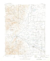
USGS Historical Topographic Map Collection · Public domain · the record · placed by its coordinates
Report this item
Hidden as soon as you tell us, everywhere it appears, before anyone reviews it.
Public domain, U.S. Geological Survey. The sheet shows the ground as the survey found it then, which is why a trail or road you know may be missing. Every sheet over this point, 1915 to 2001: USGS topoView.
From the archives
Photographs of this area held by the Library of Congress, oldest first. Every one carries the Library's own "no known restrictions on publication"; anything else is left out.


Library of Congress, Prints & Photographs Division · Public domain · the record · indexed to this place by the archive
Report this item
Hidden as soon as you tell us, everywhere it appears, before anyone reviews it.
Library of Congress, Prints & Photographs Division · Public domain · the record · indexed to this place by the archive
Report this item
Hidden as soon as you tell us, everywhere it appears, before anyone reviews it.
Library of Congress, Prints & Photographs Division · Public domain · the record · found by place name, not yet checked
Report this item
Hidden as soon as you tell us, everywhere it appears, before anyone reviews it.
Library of Congress, Prints & Photographs Division · Public domain · the record · found by place name, not yet checked
Report this item
Hidden as soon as you tell us, everywhere it appears, before anyone reviews it.
Library of Congress, Prints & Photographs Division · Public domain · the record · indexed to this place by the archive
Report this item
Hidden as soon as you tell us, everywhere it appears, before anyone reviews it.
Library of Congress, Prints & Photographs Division · Public domain · the record · found by place name, not yet checked
Report this item
Hidden as soon as you tell us, everywhere it appears, before anyone reviews it.
Library of Congress, Prints & Photographs Division · Public domain · the record · indexed to this place by the archive
Report this item
Hidden as soon as you tell us, everywhere it appears, before anyone reviews it.
Library of Congress, Prints & Photographs Division · Public domain · the record · indexed to this place by the archive
Report this item
Hidden as soon as you tell us, everywhere it appears, before anyone reviews it.
Library of Congress, Prints & Photographs Division · Public domain · the record · found by place name, not yet checked
Report this item
Hidden as soon as you tell us, everywhere it appears, before anyone reviews it.
Library of Congress, Prints & Photographs Division · Public domain · the record · indexed to this place by the archive
Report this item
Hidden as soon as you tell us, everywhere it appears, before anyone reviews it.
20 more at the Library of Congress.
Photographs near this crag
Taken within 1.5 km of this crag's map point and published under a licence that lets us show them, from Wikimedia Commons. The coordinates say where the camera was, not what it was pointed at, so some of these will be the creek or the trail rather than the rock.


Wikimedia Commons · CC BY · the record · placed by its coordinates
Report this item
Hidden as soon as you tell us, everywhere it appears, before anyone reviews it.
Wikimedia Commons · CC BY · the record · placed by its coordinates
Report this item
Hidden as soon as you tell us, everywhere it appears, before anyone reviews it.
Routes
- 1 Ninos y Viejos 5.9
- 2 Jugalicious 5.10a/b
- 3 Copacetic 5.11a/b
- 4 The Shield of Achilles 5.13a
- 5 Hanging Garden 5.10c
- 6 It's a Schu-in 5.12a
- 7 DOA 5.13a
- 8 Ya Hoo Serious 5.12c
- 9 Scratch 'n' Sniff 5.12c
- 10 The Killer Pillar 5.11d
- 11 Do the Right Thing 5.11c
- 12 Just Do It 5.12c/d
- 13 Organic Gardening 5.11
- 14 Pardon My French 5.11a
- 15 Jeremy 5.13a
- 16 Ligneous Embracer 5.9+
- 17 Rude Mood 5.12a
- 18 Time in Disguise 5.11a
- 19 Just Say No to Nancy 5.11b
- 20 Time Bandit 5.10a/b
- 21 Crack House 5.12b/c
- 22 Penal Code 5.12+
- 23 You're Busted 5.11c
- 24 Pantalones Perdidos 5.11b
- 25 My Kids Climb 5.8+
- 26 The Garden 5.8
- 27 28 K 5.11c
- 28 Unknown 5.10d
- 29 Honeycomb 5.10a
- 30 Gun Control 5.11a
- 31 Pumping Pockets 5.12a
- 32 Fine Young Cannibals 5.11b
- 33 Darla Does Buckwheat 5.11b
- 34 Come A Time 5.12d
- 35 Buffalo Chips 5.9
- 36 Rocky Mountain Oysters 5.10a
- 37 Delusions of Grandeur 5.12c
- 38 Otto 5.9+
- 39 The Terror 5.11b
- 40 The Reckoning 5.12a
- 41 Court Jester 5.12a
- 42 Unknown 5.10d
- 43 The Bottom Line 5.10b
- 44 Team Geritol 5.6
- 45 Pick Pocket 5.12c
- 46 Hot Chocolate 5.12a
- 47 Baby Bun Right 5.10b
- 48 Static Cling 5.12a
- 49 U2RNXS 5.11b
- 50 Who Dunnit Crack 5.11a/b
- 51 Double Trouble 5.12b
- 52 Palming the Porcupine 5.12b
- 53 California Crack 5.10a
- 54 Slapstick 5.12b
- 55 Feet, Don't Fail Me Now 5.11a
- Wallrus 5.8
- I+CN'? 5.7
- Big Brett the Baker's Buddy 5.9
- Bust A Move 5.12b
- Fed Ex 5.10a
- Lycra-Phobia 5.12b/c
- Cetus V11
- Ned's Highball aka Cyclops V3
- No Honor Amongst Theives V6
- Ryan's Frightmare (Big Jim) V2
- Slinky + Escalator V11
- Super Crack V0
- Unknown V0
Also within 3 km
- Penitente - Inner Canyon718 m · 78 routes and 1 boulder problem · 7,990 ft · Penitente Canyon
- Penitente - Entrance Area873 m · 63 routes · 7,971 ft · Penitente Canyon
- Canyon Road Cliffs1,378 m · 13 routes and 1 boulder problem · 8,074 ft · Witches' Canyon
- Main Canyon1,378 m · 17 routes and 1 boulder problem · 8,074 ft · Witches' Canyon
- Sidewinder Canyon2,029 m · 6 routes · 8,170 ft · Sidewinder Canyon
Straight line between the two crags' map points, each of which can be some way from its rock. For when this wall is full, or the sun has found it.
Photos from climbers
No photos here yet. If you're at the crag, yours would be the first.
Taken at the crag by climbers and published as they sent them. Each one's own location had to be within 0.5 km of this crag before we accepted it. See something that shouldn't be here? Use Report this photo under it and it's hidden at once. Anything else, write to us.
Conditions reported
Nothing reported recently.
Report what you see
Reports are dated and fade on their own: wet rock after 3 days, a bad bolt after a year. No names, no text.
Access & safety
The map point for this crag is on land managed by Private, in Private Private Land (w/ Protection). It lies inside conservation easement.
The boundary is close. Land managed by Bureau of Land Management comes within 250 m of this point, and the point is not the rock — the wall itself may be on the other side of the line. Check which before you rely on either one's rules.
Worth checking first. PAD-US records public access to this unit as “closed”. That is about getting onto the unit at all, not about climbing, and we have not checked it against Private's own page.
Land manager from USGS PAD-US (public domain), read 2026-09-29. It is the manager of the crag's map point, which can be a long way from the wall. What you may do on the rock is the manager's to say, not ours.
Nobody has yet read Private's own rules for this crag and written them down here, so treat the above as where you are, not as what you may do.
Nearby, from OpenStreetMap
- Toilets
- 996 m away (map)
Distances are a straight line from this crag's map point, which can itself be hundreds of metres off; a road may be much longer. Mapped by OpenStreetMap contributors (ODbL), so a toilet missing here may simply be unmapped. Parking here is what OSM has drawn nearby, not a guidebook's directions.
Keep Deep Cut Guide free
No ads, no paywall, no account. You can chip in directly to help keep it running.