Riggs' Hill East
46 boulder problems · clastic (Brushy Basin Shale Member of the Morrison Formation, with shale, siltstone) · 4,725 ft
What's here
VB to V6, mostly around V0.
Counted from the 46 climbs here that carry a grade. Shown only where there are at least 5 of them — below that the shape is noise.
How well located
Base placed (one source) 5 Position on wall known 18 Crag only 23
The order of the climbs along this wall is known from the open catalogue, so a few surveys go a long way: standing at Invocation to the Void, The Frolic (2 climbs, about 60 seconds on Il Teatro Grottesco) would place up to 10 more climbs between them. Survey the wall →
“Up to” because the estimate between two surveyed routes is only used when they turn out to be close enough together on the ground.
Rock, from the geologic map
Brushy Basin Shale Member of the Morrison Formation (Brushy Basin Shale Member) — clastic; shale; siltstone. Late Jurassic, about 153 to 145 million years old.
Gray, pale-green, red, and light-purple mudstone and siltstone, a few lenses of gray sandstone, limestone, and conglomerate. Thickness 200-300 ft.
This is the map unit under this crag's map point, read from the 1:100,000 sheet (Day and others, 1999, U.S. Geological Survey Open-File Report 99-0427). The point can be a few hundred metres from the rock, a cliff often stands on the line between two units, and at that scale a line on the map is about 100 m wide on the ground, so the wall itself may be the neighbouring unit. Every crag on this unit: Brushy Basin Shale Member of the Morrison Formation. Geology data: Macrostrat (CC BY 4.0), serving USGS and Colorado Geological Survey maps.
On the map since 1934
The USGS has mapped this ground since 1934. 17 historical sheets cover this crag's map point; the oldest is below.
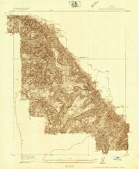
USGS Historical Topographic Map Collection · Public domain · the record · placed by its coordinates
Report this item
Hidden as soon as you tell us, everywhere it appears, before anyone reviews it.
Public domain, U.S. Geological Survey. The sheet shows the ground as the survey found it then, which is why a trail or road you know may be missing. Every sheet over this point, 1934 to 1981: USGS topoView.
In print since 1877
1877 Geologic Map of Colorado (Hayden), high-resolution scan · F. V. Hayden; scan by the Colorado Geological Survey · 1877
Geological and geographical atlas of Colorado and portions of adjacent territory · F. V. Hayden, U.S. Geological and Geographical Survey of the Territories · 1877
Free to read: public domain or government work. About Grand Junction Area as a whole, not this wall. More in the reading room.
Routes
Almost Vintage Boulder
- 1 Not Classic V2
Argile Boulder
- 1 Skybosh V5-
- 2 The 20th Variation V3
Il Teatro Grottesco
- 1 Invocation to the Void V3
- 2 Vastarien V0+
- 3 Ten Steps to Thin Mountain V0-
- 4 His Shadow Shall Rise (To a Higher House) V0
- 5 Noctuary V1
- 6 The Glamour V0
- 7 The Shadow at the Bottom of the World V0+
- 8 This Degenerate Little Town V0
- 9 The Unholy City V1
- 10 Sideshow V0+
- 11 My Work is Not Yet Done V0
- 12 The Frolic V0
Vintage Block
- 1 V2 V2
- 2 V5- V4
- 3 Clockwork V5-6
- 4 Before You Hueco V4
Elsewhere at this crag
- Abattoir V3
- Abattoir - NE Face V0-
- Abattoir - Right V3
- Alcatraz V4-5
- An Indifference to Ascension V6
- Butter Face V3
- Butterfly V0+
- Chip Happy V-easy
- Chipped Paradise V0
- Funky Traverse V5
- Hairy Lip V3
- He-Man Chip V5
- Iffy If V3
- Ill at Ease V2+
- Linguistics V4
- Mr. Original V1
- Petoria V4-5
- Praying Mantel V1
- Pull Around This V3
- Razor Rock V0+
- Sideshow V6+
- Spread Eagle V1-
- Stairway V1+
- Take it to the Hole V1
- Terrible Lizard V4
- This is Something Else V3
- V4 V4
Also within 3 km
- Riggs' Hill Central327 m · 49 boulder problems · 4,824 ft
- Escondido Circle474 m · 12 boulder problems · 4,722 ft
- Riggs' Hill West509 m · 1 route and 19 boulder problems · 4,889 ft
- Water Tower Hill1,179 m · 17 boulder problems · 4,786 ft · South Camp
- Canyon Rim Drive1,882 m · 9 boulder problems · 4,866 ft · South Camp
- Red Canyon2,295 m · 6 routes · 4,877 ft · Colorado National Monument
Straight line between the two crags' map points, each of which can be some way from its rock. For when this wall is full, or the sun has found it.
Photos from climbers
No photos here yet. If you're at the crag, yours would be the first.
Taken at the crag by climbers and published as they sent them. Each one's own location had to be within 0.5 km of this crag before we accepted it. See something that shouldn't be here? Use Report this photo under it and it's hidden at once. Anything else, write to us.
Conditions reported
Nothing reported recently.
Report what you see
Reports are dated and fade on their own: wet rock after 3 days, a bad bolt after a year. No names, no text.
Access & safety
We don't know who manages this ground: PAD-US doesn't map this point as protected land, which most often means it is private. Find out whose it is before you go.
Nobody has yet read the land manager's own rules for this crag and written them down here, so treat the above as where you are, not as what you may do.
Nearby, from OpenStreetMap
- Mapped parking
- 302 m away (map)
- Campsite
- The Camp, 4,781 m away (map)
Distances are a straight line from this crag's map point, which can itself be hundreds of metres off; a road may be much longer. Mapped by OpenStreetMap contributors (ODbL), so a toilet missing here may simply be unmapped. Parking here is what OSM has drawn nearby, not a guidebook's directions.
Keep Deep Cut Guide free
No ads, no paywall, no account. You can chip in directly to help keep it running.