Lower Canyon
1 boulder problem · arkose (Minturn Fm in west-central and south-central and other units, with conglomerate, shale) · 8,359 ft
How well located
Crag only 1
No route here has its own point yet. The map pin is the crag. At the wall? Survey it: 30 seconds per route.
Rock, from the geologic map
Minturn Fm in west-central and south-central and other units (Minturn Formation) — arkose, conglomerate, shale, minor limestone. Pennsylvanian, about 312 to 306 million years old.
Arkosic sandstone, conglomerate, shale, and limestone. Includes Madera Fm and Sharpsdale Fm of Chronic (1958) in Sangre de Cristo Range and Gothic Fm of Langenheim (1952) in Elk Mountains. Other units of Middle Pennsylvanian age.
This is the map unit under this crag's map point, read from the 1:500,000 sheet (Horton and others, 2017, U.S. Geological Survey Data Series 1052). The point can be a few hundred metres from the rock, a cliff often stands on the line between two units, and at that scale a line on the map is about 500 m wide on the ground, so the wall itself may be the neighbouring unit. Every crag on this unit: Minturn Fm in west-central and south-central and other units. Geology data: Macrostrat (CC BY 4.0), serving USGS and Colorado Geological Survey maps.
On the map since 1934
The USGS has mapped this ground since 1934. 21 historical sheets cover this crag's map point; the oldest is below.
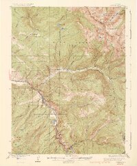
USGS Historical Topographic Map Collection · Public domain · the record · placed by its coordinates
Report this item
Hidden as soon as you tell us, everywhere it appears, before anyone reviews it.
Public domain, U.S. Geological Survey. The sheet shows the ground as the survey found it then, which is why a trail or road you know may be missing. Every sheet over this point, 1934 to 1980: USGS topoView.
Routes
Also within 3 km
- Cemetery Blocks0 m · 11 boulder problems · 8,359 ft
- Grouse Mountain Grill0 m · 2 boulder problems · 8,359 ft
Straight line between the two crags' map points, each of which can be some way from its rock. For when this wall is full, or the sun has found it.
Photos from climbers
No photos here yet. If you're at the crag, yours would be the first.
Taken at the crag by climbers and published as they sent them. Each one's own location had to be within 0.5 km of this crag before we accepted it. See something that shouldn't be here? Use Report this photo under it and it's hidden at once. Anything else, write to us.
Conditions reported
Nothing reported recently.
Report what you see
Reports are dated and fade on their own: wet rock after 3 days, a bad bolt after a year. No names, no text.
Access & safety
The map point for this crag is on land managed by Colorado Parks & Wildlife (state), in Vail Deer Underpass State Wildlife Area. It lies inside state conservation area.
The boundary is close. Land managed by White River National Forest comes within 250 m of this point, and the point is not the rock — the wall itself may be on the other side of the line. Check which before you rely on either one's rules.
Land manager from USGS PAD-US (public domain), read 2026-09-29. It is the manager of the crag's map point, which can be a long way from the wall. What you may do on the rock is the manager's to say, not ours.
Rules for all Colorado Parks & Wildlife land
- Fees
- Every Colorado state park requires an entrance pass for motor vehicles. A daily vehicle pass is $4 to $17 depending on the park; an individual pass covers entry on foot or bike.
- Reservations
- Eldorado Canyon runs timed-entry vehicle reservations on summer weekends and holidays; see the park's own page. Other parks do not require one to enter.
- Permits
- A daily pass is valid until noon on the day after purchase. The annual Keep Colorado Wild pass is $29 and is bought with a vehicle registration.
Read on Colorado Parks & Wildlife's own pages, checked 2026-09-29 by John Crawford. What they require, in full, or their own climbing page. These apply to the manager's whole holding; anything specific to this crag is above.
Nearby, from OpenStreetMap
- Toilets
- 1,057 m away (map)
Distances are a straight line from this crag's map point, which can itself be hundreds of metres off; a road may be much longer. Mapped by OpenStreetMap contributors (ODbL), so a toilet missing here may simply be unmapped. Parking here is what OSM has drawn nearby, not a guidebook's directions.
Keep Deep Cut Guide free
No ads, no paywall, no account. You can chip in directly to help keep it running.