Little Weston Wall
7 routes · Biotite gneiss · 10,270 ft
What's here
5.7 to 5.11, mostly around 5.10.
Counted from the 7 climbs here that carry a grade. Shown only where there are at least 5 of them — below that the shape is noise.
How well located
Position on wall known 7
No route here has its own point yet. The map pin is the crag. At the wall? Survey it: 30 seconds per route.
The order of the climbs along this wall is known from the open catalogue, so a few surveys go a long way: standing at Bashful, Sleepy (2 climbs, about 60 seconds) would place up to 5 more climbs between them. Survey the wall →
“Up to” because the estimate between two surveyed routes is only used when they turn out to be close enough together on the ground.
Rock, from the geologic map
Biotite gneiss. Paleoproterozoic, about 2,500 to 1,600 million years old.
Mostly gray to dark-gray, fine- to medium-grained, moderately foliated to strongly foliated and layered gneiss and schist. Composed of quartz, plagioclase, microcline, and biotite; locally contains hornblende, sillimanite, and garnet. Accessory minerals are rutile, sphene, apatite, zircon, and magnetite. Sillimanite-bearing biotite schist (metapelite) crops out in and near the Twin Lakes mining district. Migmatitic in most places; contains numerous light-colored layers and lenses (leucosomes) typically 0.1–10 cm thick, although locally may be much thicker. In most places, leucosome bodies form less than half of rock, have sharp contacts with host rock, show much pinch and swell, and in some places are strongly folded. Leucosomes are composed of equigranular, massive to weakly foliated, white to light-gray microcline-plagioclase-quartz rock containing less than 5 percent biotite; accessory minerals are muscovite, opaque minerals, sphene, apatite, garnet, and zircon. Formation of leucosomes may be due to either injection or in situ partial melting (anatexis) (Johannes and Gupta, 1982; Olsen, 1982). In the case of partial melting, biotite gneiss adjacent to leucosomes commonly has biotite-rich selvages representing refractory material remaining after partial melting. Some areas mapped as biotite gneiss may include small bodies of granitic rock. Unit undated in map area, but similar rocks in the Gore Range and western Front Range, northeast of the map area, have a U-Pb zircon age of about 1,750–1,785 Ma (Kellogg and others, 2008, 2011), which represents the age of the source rocks from which detritus that comprises the sedimentary protolith was derived. In the same areas, U-Pb zircon geochronology indicates that formation of migmatite (partial melting) occurred about 1,695 Ma, which is also the approximate time at which many pegmatites in and near these areas formed (Kellogg and others, 2011)
This is the map unit under this crag's map point, read from the 1:100,000 sheet (Kellogg and others, 2017, U.S. Geological Survey Scientific Investigations Map 3382). The point can be a few hundred metres from the rock, a cliff often stands on the line between two units, and at that scale a line on the map is about 100 m wide on the ground, so the wall itself may be the neighbouring unit. Every crag on this unit: Biotite gneiss. Geology data: Macrostrat (CC BY 4.0), serving USGS and Colorado Geological Survey maps.
On the map since 1889
The USGS has mapped this ground since 1889. 24 historical sheets cover this crag's map point; the oldest is below.
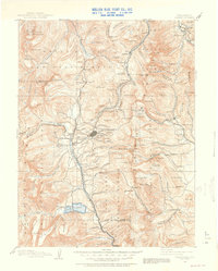
USGS Historical Topographic Map Collection · Public domain · the record · placed by its coordinates
Report this item
Hidden as soon as you tell us, everywhere it appears, before anyone reviews it.
Public domain, U.S. Geological Survey. The sheet shows the ground as the survey found it then, which is why a trail or road you know may be missing. Every sheet over this point, 1889 to 1994: USGS topoView.
From the archives
Photographs of this area held by the Library of Congress, oldest first. Every one carries the Library's own "no known restrictions on publication"; anything else is left out.


Library of Congress, Prints & Photographs Division · Public domain · the record · indexed to this place by the archive
Report this item
Hidden as soon as you tell us, everywhere it appears, before anyone reviews it.
Library of Congress, Prints & Photographs Division · Public domain · the record · indexed to this place by the archive
Report this item
Hidden as soon as you tell us, everywhere it appears, before anyone reviews it.
Library of Congress, Prints & Photographs Division · Public domain · the record · indexed to this place by the archive
Report this item
Hidden as soon as you tell us, everywhere it appears, before anyone reviews it.
Library of Congress, Prints & Photographs Division · Public domain · the record · indexed to this place by the archive
Report this item
Hidden as soon as you tell us, everywhere it appears, before anyone reviews it.
Library of Congress, Prints & Photographs Division · Public domain · the record · indexed to this place by the archive
Report this item
Hidden as soon as you tell us, everywhere it appears, before anyone reviews it.
Library of Congress, Prints & Photographs Division · Public domain · the record · indexed to this place by the archive
Report this item
Hidden as soon as you tell us, everywhere it appears, before anyone reviews it.
Library of Congress, Prints & Photographs Division · Public domain · the record · indexed to this place by the archive
Report this item
Hidden as soon as you tell us, everywhere it appears, before anyone reviews it.
Library of Congress, Prints & Photographs Division · Public domain · the record · indexed to this place by the archive
Report this item
Hidden as soon as you tell us, everywhere it appears, before anyone reviews it.
Library of Congress, Prints & Photographs Division · Public domain · the record · indexed to this place by the archive
Report this item
Hidden as soon as you tell us, everywhere it appears, before anyone reviews it.
Library of Congress, Prints & Photographs Division · Public domain · the record · indexed to this place by the archive
Report this item
Hidden as soon as you tell us, everywhere it appears, before anyone reviews it.
13 more at the Library of Congress.
Routes
Also within 3 km
Straight line between the two crags' map points, each of which can be some way from its rock. For when this wall is full, or the sun has found it.
Photos from climbers
No photos here yet. If you're at the crag, yours would be the first.
Taken at the crag by climbers and published as they sent them. Each one's own location had to be within 0.5 km of this crag before we accepted it. See something that shouldn't be here? Use Report this photo under it and it's hidden at once. Anything else, write to us.
Conditions reported
Nothing reported recently.
Report what you see
Reports are dated and fade on their own: wet rock after 3 days, a bad bolt after a year. No names, no text.
Access & safety
The map point for this crag is on land managed by San Isabel National Forest (federal). It lies inside national forest.
Land manager from USGS PAD-US (public domain), read 2026-09-29. It is the manager of the crag's map point, which can be a long way from the wall. What you may do on the rock is the manager's to say, not ours.
Rules for all Pike-San Isabel National Forests land
- Fees
- No entrance fee for the Pike-San Isabel National Forests or the Cimarron and Comanche National Grasslands. Fees apply at campgrounds and day-use areas operated by the forest's concessionaire, paid on site.
- Overnight
- On the Leadville, Salida and San Carlos districts of the San Isabel, camping at any location within the same 20-mile radius for more than 14 days in a continuous 30-day period is prohibited. No camping within 100 feet of water outside a developed or designated site.
Read on Pike-San Isabel National Forests's own pages, checked 2026-09-29 by John Crawford. What they require, in full, or their own climbing page. These apply to the manager's whole holding; anything specific to this crag is above.
Nearby, from OpenStreetMap
- Campsite
- Unnamed, 1,961 m away (map)
Distances are a straight line from this crag's map point, which can itself be hundreds of metres off; a road may be much longer. Mapped by OpenStreetMap contributors (ODbL), so a toilet missing here may simply be unmapped. Parking here is what OSM has drawn nearby, not a guidebook's directions.
Keep Deep Cut Guide free
No ads, no paywall, no account. You can chip in directly to help keep it running.