Garden of the Gods Bouldering
49 boulder problems · sandstone (Lyons Formation fins; Fountain Formation also exposed) · 6,336 ft
What's here
VB to V8, with no single grade dominating.
Counted from the 49 climbs here that carry a grade. Shown only where there are at least 5 of them — below that the shape is noise.
How well located
Position on wall known 42 Crag only 7
No route here has its own point yet. The map pin is the crag. At the wall? Survey it: 30 seconds per route.
The order of the climbs along this wall is known from the open catalogue, so a few surveys go a long way: standing at Low Traverse into Slapper, Unknown Barn Door Problem, Nose Lunge (3 climbs, about 90 seconds on Mongoose Block) would place up to 14 more climbs between them. Survey the wall →
“Up to” because the estimate between two surveyed routes is only used when they turn out to be close enough together on the ground.
Rock, from the geologic map
Mesozoic and Paleozoic rocks — siliciclastic. about 541 to 66 million years old.
Mainly as in Mesozoic unit (MZ) plus Permian and Pennsylvanian Fms
This is the map unit under this crag's map point, read from the 1:500,000 sheet (Horton and others, 2017, U.S. Geological Survey Data Series 1052). The point can be a few hundred metres from the rock, a cliff often stands on the line between two units, and at that scale a line on the map is about 500 m wide on the ground, so the wall itself may be the neighbouring unit. The rock named at the top of this page comes from the public geology of this area; this card is the map's answer. Every crag on this unit: Mesozoic and Paleozoic rocks. Geology data: Macrostrat (CC BY 4.0), serving USGS and Colorado Geological Survey maps.
On the map since 1893
The USGS has mapped this ground since 1893. 37 historical sheets cover this crag's map point; the oldest is below.
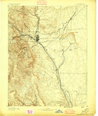
USGS Historical Topographic Map Collection · Public domain · the record · placed by its coordinates
Report this item
Hidden as soon as you tell us, everywhere it appears, before anyone reviews it.
Public domain, U.S. Geological Survey. The sheet shows the ground as the survey found it then, which is why a trail or road you know may be missing. Every sheet over this point, 1893 to 1994: USGS topoView.
In print since 1877
1877 Geologic Map of Colorado (Hayden), high-resolution scan · F. V. Hayden; scan by the Colorado Geological Survey · 1877
Geological and geographical atlas of Colorado and portions of adjacent territory · F. V. Hayden, U.S. Geological and Geographical Survey of the Territories · 1877
Free to read: public domain or government work. About Colorado Springs as a whole, not this wall. More in the reading room.
From the archives
Photographs of this area held by the Library of Congress, oldest first. Every one carries the Library's own "no known restrictions on publication"; anything else is left out.


Library of Congress, Prints & Photographs Division · Public domain · the record · indexed to this place by the archive
Report this item
Hidden as soon as you tell us, everywhere it appears, before anyone reviews it.
Library of Congress, Prints & Photographs Division · Public domain · the record · indexed to this place by the archive
Report this item
Hidden as soon as you tell us, everywhere it appears, before anyone reviews it.
Library of Congress, Prints & Photographs Division · Public domain · the record · indexed to this place by the archive
Report this item
Hidden as soon as you tell us, everywhere it appears, before anyone reviews it.
Library of Congress, Prints & Photographs Division · Public domain · the record · indexed to this place by the archive
Report this item
Hidden as soon as you tell us, everywhere it appears, before anyone reviews it.
Library of Congress, Prints & Photographs Division · Public domain · the record · indexed to this place by the archive
Report this item
Hidden as soon as you tell us, everywhere it appears, before anyone reviews it.
Library of Congress, Prints & Photographs Division · Public domain · the record · indexed to this place by the archive
Report this item
Hidden as soon as you tell us, everywhere it appears, before anyone reviews it.
Library of Congress, Prints & Photographs Division · Public domain · the record · indexed to this place by the archive
Report this item
Hidden as soon as you tell us, everywhere it appears, before anyone reviews it.
Library of Congress, Prints & Photographs Division · Public domain · the record · indexed to this place by the archive
Report this item
Hidden as soon as you tell us, everywhere it appears, before anyone reviews it.
Library of Congress, Prints & Photographs Division · Public domain · the record · indexed to this place by the archive
Report this item
Hidden as soon as you tell us, everywhere it appears, before anyone reviews it.
Library of Congress, Prints & Photographs Division · Public domain · the record · indexed to this place by the archive
Report this item
Hidden as soon as you tell us, everywhere it appears, before anyone reviews it.
26 more at the Library of Congress.
Photographs near this crag
Taken within 1.5 km of this crag's map point and published under a licence that lets us show them, from Wikimedia Commons. The coordinates say where the camera was, not what it was pointed at, so some of these will be the creek or the trail rather than the rock.


Wikimedia Commons · CC BY · the record · placed by its coordinates
Report this item
Hidden as soon as you tell us, everywhere it appears, before anyone reviews it.
Wikimedia Commons · CC BY-SA · the record · placed by its coordinates
Report this item
Hidden as soon as you tell us, everywhere it appears, before anyone reviews it.
Wikimedia Commons · CC BY-SA · the record · placed by its coordinates
Report this item
Hidden as soon as you tell us, everywhere it appears, before anyone reviews it.
Wikimedia Commons · CC BY-SA · the record · placed by its coordinates
Report this item
Hidden as soon as you tell us, everywhere it appears, before anyone reviews it.
Wikimedia Commons · CC BY · the record · placed by its coordinates
Report this item
Hidden as soon as you tell us, everywhere it appears, before anyone reviews it.
Wikimedia Commons · CC BY · the record · placed by its coordinates
Report this item
Hidden as soon as you tell us, everywhere it appears, before anyone reviews it.
Wikimedia Commons · Public domain · the record · placed by its coordinates
Report this item
Hidden as soon as you tell us, everywhere it appears, before anyone reviews it.
Wikimedia Commons · CC BY · the record · placed by its coordinates
Report this item
Hidden as soon as you tell us, everywhere it appears, before anyone reviews it.
Wikimedia Commons · Public domain · the record · placed by its coordinates
Report this item
Hidden as soon as you tell us, everywhere it appears, before anyone reviews it.
Wikimedia Commons · CC BY · the record · placed by its coordinates
Report this item
Hidden as soon as you tell us, everywhere it appears, before anyone reviews it.
Wikimedia Commons · CC BY · the record · placed by its coordinates
Report this item
Hidden as soon as you tell us, everywhere it appears, before anyone reviews it.
Wikimedia Commons · Public domain · the record · placed by its coordinates
Report this item
Hidden as soon as you tell us, everywhere it appears, before anyone reviews it.
18 more on Commons.
Routes
Arch Boulder (aka Ground Arch Boulder)
- 1 Downclimb (North Slab) V-easy
- 2 North Arête V0
- 3 Static Rehab V5+
- 4 West Face Left V2
- 5 One Day They'll Know V3
- 6 West Crack V0+
- 7 Why Are You Upside Down?(West Crack Footlead) V2+
- 8 Don’t Touch the Crack Rock! V2-3
- 9 Wise Up V3
- 10 South Arête V1-
- 11 Run N Jump (South Face) V0-1
- 12 South Face Alt V3
- 13 Traverse V2+
- 14 Arch Route V-easy
Boulder (aka Fang Boulder), The
- 1 Plundercling V2
- 2 South Face V3
- 3 East Face Crimps V3
- 4 The Interview V4
Miscellaneous Bouldering
- 1 Roadside Attraction V-easy
Mongoose Block
- 1 Low Traverse into Slapper V8
- 2 Left Traverse into B*%€# Slap V8-9
- 3 Unknown V4 V4
- 4 Unknown Variation of V4 on West Overhang V4
- 5 Swiss Cheese V4
- 6 Off The Rails V0+
- 7 The Prow (Stand) V0+
- 8 Unknown V7 aka Slapper V7
- 9 Slapper Right variation V8-
- 10 Batman Went To Space V1+
- 11 Get Your Training Wheels V0
- 12 Mighty Mongoose V0
- 13 Unknown Barn Door Problem V1
- 14 Unknown (left of southeast arete) V1+
- 15 East Overhang of Mongoose Block V7-8
- 16 Unknown (Compression Northeast) V3-
- 17 Nose Lunge V4
Snake Perch
- 1 From Rung to Rung V1-
- 2 The Hangboard V3-
Traverse Boulder (aka Trail Blob Boulder)
- 1 Unknown Dyno V3+
- 2 Low R->L Crimp Traverse (Lockdown) V8
- 3 Traverse V6
- 4 Tying the Knott V3
- 5 Unknown V3
Elsewhere at this crag
- Long Traverse V6
- Look Ma, No Hands V8
- Mongoose Block West Overhang V2
- Pick of the Week V6
- Unnamed V3
- Winter Warmer Traverse V0-
Also within 3 km
- Kindergarten Rock160 m · 29 routes · 6,539 ft
- Easter Rock257 m · 4 routes · 6,571 ft
- Montezuma Tower388 m · 3 routes · 6,444 ft
- Three Graces393 m · 3 routes · 6,465 ft
- South Gateway Rock474 m · 25 routes and 1 boulder problem · 6,541 ft
- Pigeon Rock492 m · 1 route · 6,439 ft
Straight line between the two crags' map points, each of which can be some way from its rock. For when this wall is full, or the sun has found it.
Photos from climbers
No photos here yet. If you're at the crag, yours would be the first.
Taken at the crag by climbers and published as they sent them. Each one's own location had to be within 0.5 km of this crag before we accepted it. See something that shouldn't be here? Use Report this photo under it and it's hidden at once. Anything else, write to us.
Conditions reported
Nothing reported recently.
Report what you see
Reports are dated and fade on their own: wet rock after 3 days, a bad bolt after a year. No names, no text.
Access & safety
The map point for this crag is on land managed by City of Colorado Springs (local government), in Garden Of The Gods Park. It lies inside local park.
Land manager from USGS PAD-US (public domain), read 2026-09-29. It is the manager of the crag's map point, which can be a long way from the wall. What you may do on the rock is the manager's to say, not ours.
- Managed by
- City of Colorado Springs (Garden of the Gods Park)
- Fees
- Free to enter.
- Climbing permit
- A free climbing permit is required (online; good for all city parks that allow climbing); carry proof for any park official. Parties of 2 or more.
- Hours
- 5am-10pm May 1-Oct 31; 5am-9pm Nov 1-Apr 30.
- Rules
- All chalk and chalk substitutes are prohibited. Do not climb sandstone when wet. Seasonal closures are marked with signs on the closed routes.
- Dogs
- The park asks climbers to leave pets at home.
- County
- El Paso County
Checked 2026-09-29 against source 1. Rules change: confirm with the land manager.
Nearby, from OpenStreetMap
- Toilets
- 388 m away (map)
- Mapped parking
- 416 m away (map)
Distances are a straight line from this crag's map point, which can itself be hundreds of metres off; a road may be much longer. Mapped by OpenStreetMap contributors (ODbL), so a toilet missing here may simply be unmapped. Parking here is what OSM has drawn nearby, not a guidebook's directions.
Keep Deep Cut Guide free
No ads, no paywall, no account. You can chip in directly to help keep it running.